Please excuse the quality. I appropriated most of my Astoria JPGs from auctions on eBay--auctions that I LOST. So unfortunately, I don't own and can't rescan the postcards.
These postcards show two opposite views, circa 1915, of the junction of Van Alst St. (now 21st St) at Main St. (now Main Ave.) Franklin St. (now 27th Ave), Flushing Ave. (now Astoria Blvd.) and Newtown Ave. (An 1874 map shows this area, albeit many years before these photos were taken. The building sites are marked in orange.)
 Above, Facing East. This postcard shows the junction of Flushing Ave. (left fork)
and Newtown Ave. (right fork).
The far side of the triangular block is Crescent Street, where you can see the
red brick spire of Our Lady of Mt. Carmel school just to
the left of the central block of buildings.
The street branching off the right side of the card is Van Alst.
Above, Facing East. This postcard shows the junction of Flushing Ave. (left fork)
and Newtown Ave. (right fork).
The far side of the triangular block is Crescent Street, where you can see the
red brick spire of Our Lady of Mt. Carmel school just to
the left of the central block of buildings.
The street branching off the right side of the card is Van Alst.
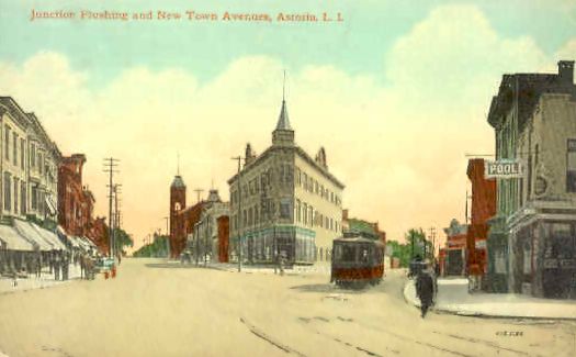
Below, Facing West. The left fork (with trolley) is Main and the right fork is Franklin. The trolley traveled down Main to Fulton and to the ferry which traveled between Hallets Point and 92nd Street in Manhattan.

http://www.pefagan.com/gen/astmaps/ast_sq1.html
queens maps